Local News
Area Colleges, Schools Closed Tuesday
April 26th 2011 by Unknown
Three Rivers College is closed Tuesday at its main campus in Poplar Bluff and campuses in Dexter, Sikeston, Malden and Kennett.
In addition, Central Methodist University classes in Poplar Bluff have been cancelled and Murray State University in Kentucky is closed on Tuesday due to storm damage in that region from Monday night.
Stoddard County Schools
Advance
Bell City
Puxico
Other Schools
Bunker R-III
Chaffee Head Start
Clearwater R-I Schools Delta R-V Schools
Doniphan R-I Schools East Carter County R-II
Greenville R-II
Lesterville R-IV
Marquand-Zion R-VI
Meadow Heights R-II
Naylor R-II Schools
Neelyville R-IV
New Hope Christian Academy
New Salem Baptist Academy
Oran R-III
Poplar Bluff R-I
Ripley County R-IV Schools
South Iron County R-I
Southern Reynolds Co. R-II
Twin Rivers R-X
Van Buren R-I
Westwood Baptist Academy
Woodland R-IV
Zalma R-V
Last Updated on April 26th 2011 by Unknown
https://showmetimes.com/Blogpost/uij2/Area-Colleges-Schools-Closed-Tuesday
Lake Closes Some Areas Due To Flood
April 25th 2011 by News
By Annabeth Miller, ShowMe Times Editor
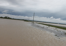
WAPPAPELLO, Mo. - The floods in Southeast Missouri have not only had a major affect on rivers and streams, but on the region’s largest lake.
Officials with the U.S. Army Corps of Engineers at Lake Wappapello reported on Monday that most of the recreational areas at the lake are now closed to the public.
Doug Nichols with the Corps reported to the ShowMe Times that on Sunday campers were evacuated from both the Greeneville and People’s Creek campgrounds and those two recreation areas are now closed due to the flooding.
In addition, Nichols reported that part of Chaonia Landng, Holiday Landing, the Rockwood Point beach and recreation area are all closed due to flood issues.
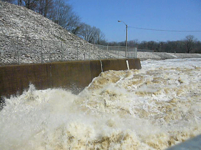
.As of 2 p.m. on Monday, lake level was 379.08 feet. Nichols said the summer pool at the lake is normally 360 feet. The lake is expected to crest at 384.0 feet Friday, April 29 without additional rain. More heavy rainfall is predicted to occur over the next several days. The discharge at the spillway will be increased to its maximum controlled release of 10,000 cfs (cubit feet per second) once the lake reaches 380.0 feet.
“We are protecting lots of folks and crops down streem (from the lake),” Nichols said of the lake levels. “So we are doing our mission.” Wappapello is a reservoir on the St. Francios River and was created in 1941 as a flood control project on the river.
Wapppapello Lake annually provides an estimated $3.9 million in flood protection to agricultural lands and developed areas along the St. Francis River Wappapello has Over 44,000 acres of public lands and water for hunting, fishing, swimming, boating, camping and picnicking.
Nichols advises that visitors to the lake should to use caution in flash flood-prone areas and when traveling low roads near the lake. Boaters are urged to use caution when on the lake. Inflows have caused floating debris such as logs, limbs, etc., on the lake.
For up-to-date lake information and facility closings, call the Wappapello Lake Hotline at (573) 222-8139 or toll-free at 1-877-LAKE-INFO (1-877-525-3463) or call the Wappapello Lake Management Office at (573) 222-8562.
Photo Above: The water flows fast at Wappapello during the March 2008 flood. The lake is expected to crest later this week at 384 feet. (Photo by April Isbell. Thanks, April!
Last Updated on April 25th 2011 by News
https://showmetimes.com/Blogpost/uij0/Lake-Closes-Some-Areas-Due-To-Flood
Mandatory Evacuations In 'Bluff Flood Area
April 25th 2011 by News
A SMT News Report
The National Weather Service continues to keep a close watch over the rivers and contributories in Southeast Missouri as residents prepare for more storms. Lakes, Rivers and streams are under severe stress and are swollen to exceeding design limits.
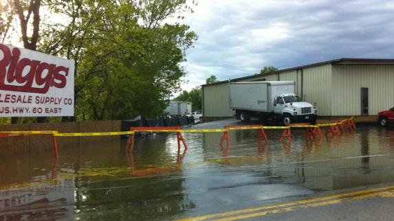
Poplar Bluff has seen the initial threats of flooding in the low elevation areas of the south end of that community. Businesses and homes are all being affected by a mandatory evacuation of areas surrounding the Black River. It is undetermined how many of the 17,000 residents of this community will be effected by the flood waters.
Local businesses on Ditch Road in Poplar Bluff have taken steps to move their properties to higher ground throughout the day as the water rises. The Ditch Road area is comprised of areas south of Poplar Bluff and east of Highway WW.
There have been several reports of the levee having leaks and weakening throughout the day. Many authorities are predicting a “catastrophic failure” of the levee system.
Poplar Bluff authorities have established a shelter for local residence at the Black River Coliseum for victims of flooding.
Last Updated on April 25th 2011 by Staff Writer
https://showmetimes.com/Blogpost/uiir/Mandatory-Evacuations-In-Bluff-Flood-Area
MoDOT Announces Road Closings
April 25th 2011 by News

BREAKING NEWS
1 p.m., Monday, April 25, 2011
A SMT News Report
SIKESTON, Mo. - The Missouri Department of Transportation District Office in Sikeston at 1 p.m., Monday, April 25 the following roadways in Southeast Missouri are closed to the recent flooding. Several routes have water over them but have not been closed and motorists are urged to use extreme caution and plan alternate routes.
Routes that are closed or have water over the roadways include:
Bollinger County
•· Route 51 - from Castor River to Zalma
•· Route C - from Route BB to Route V
•· Route EE - at Route K near Sedgewickville
•· Route H - from Route 51 to Route FF
•· Route P
•· Route V
•· Route W
Butler County
•· Route 91 - Diversion Channel to Route T
•· Route 53 - from Route 51 to Route 142
•· Route 142
•· Route 158 - from Route BB to Route 142
•· Route BB
•· Route CC
•· Route DD
•· Route HH
•· Route N - near Oglesville from Route 53 to Route 51
•· Route U
•· Route W
•· Route Z
Cape Girardeau County
•· Route N - Intersection of N, U and T to Route F
•· Route OO - from Route Z to Route 34
•· Route P - near Perkins
•· Route P - between Delta and Perkins
•· Route RA
•· Route T - Intersection of N, U and T to Route F
•· Route U - from Route N to Route A Dunklin County
•· Route B - from CRD 322 to Route 62
•· Route DD - from Route 53 to the end of state maintenance
•· Route H - from Route J to Route U
•· Route H south - from Route J to Route 53
•· Route U - from Route U in Stoddard County to County Road 102 in Dunklin County
•· Route WW
Madison County
•· Route F - from Route V to Route A
•· Route V - from Route F to the end of Route F
Mississippi County
•· Route 62 - City of Bertrand
•· Route 75
•· Route 77 - at the Mississippi River
•· Route 77 - from Route DD to Route A
•· Route 80 - from the Mississippi River to Belmont
•· Route 80 West - from I-55 to Route 61
•· Route 102
•· Route A
•· Route AA
•· Route B
•· Route F
•· Route NN - intersection of Routes NN and 62
•· Route OO
•· Route Y
New Madrid County
•· Route 153 - Route D to CRD 794
•· Route 61 - approximately two miles south of Sikeston
•· Route 61 - at County Road 502
•· Route 162 - at the Mississippi River
•· Route AA - at County Road 807
•· Route D - from Route 153 to 2 miles west •· Route E
•· Route FF
•· Route H - from Route D to CRD 794
•· Route P - from Route 61 to Route BB
•· Route V
•· Route WW
Pemiscot County
•· Route 162 - at the Mississippi River
Perry County
•· Route A - from County Road 460 to County Road 444
•· Route E
Scott County
•· Route BB - Intersection of Route Y and Route 114
•· Route CC
•· Route E -from Route N to end of road at Commerce
•· Route EE - from Delta to Chaffee
•· Route HH
•· Route N - from Route D
•· Route P
•· Route Z - from Route 61 to Vanduser
•· Route W - Route P to Oran City limits
Stoddard County
•· Route 114
•· Route A - west of Charter Oak
•· Route AB
•· Route BB
•· Route C
•· Route D - Route 25 to CRD 751
•· Route DD
•· Route E - Route FF/E Junction to Route N/E at Circle City
•· Route F
•· Route FF - east of Dexter and south of Route 60
•· Route H
•· Route J
•· Route K
•· Route MM - from Route U in Stoddard County to County Road 102 in Dunklin County
•· Route N - to Route A
•· Route O - between County Road 309 and County Road 337
•· Route P
•· Route T - from Route 51 to the intersection of Routes T and J
•· Route U - Route H to CRD 667
•· Route V
•· Route WW
•· Route Y - from Route AB to Route Z
•· Route Z - from Route VV to east city limits of Bernie
•· Route Z - west of Route 153
•· Route ZZ
•· Intersection of Route E and N
Wayne County
•· Route 49 - from Mill Spring to Route A Junction
•· Route 143 - near Sam A. Baker State Park entrance
•· Route 143 - from Route 34 to Route 49
•· Route FF - from Route U to Route 67
•· Route TT
•· Route Z
For more information, please contact MoDOT's Customer Service Center toll-free at 1-888-ASK-MODOT (1-888-275-6636) or visit the Traveler Information Map at: http://maps.modot.mo.gov/timi/index.aspx?district=10
Last Updated on April 25th 2011 by News
https://showmetimes.com/Blogpost/uiiq/MoDOT-Announces-Road-Closings
Governor Activates National Guard
April 25th 2011 by News

By Annabeth Miller, ShowMe Times Editor
JEFFERSON CITY, Mo. – Missouri’s governor activated the National Guard to help respond to flooding and threats to levees in Southeast Missouri.
Gov. Jay Nixon today activated the Missouri National Guard to help with response efforts in southern and Southeast Missouri impacted by flooding and threats to levees after recent rains.
"I have directed Maj. General Danner to immediately move Guard units into place where they can best help in protecting health and property," Nixon said. "The Citizen-Soldiers and Airmen of the Missouri National Guard have demonstrated their ability to help with natural disasters numerous times over the years, most recently in the work they did before, during, and after the blizzard and record snowstorm this winter. I have full confidence in the Guard to assist local emergency officials around the state."
Under the Nixon's order, Guard units will be deployed immediately to support local emergency agencies. Nixon has been receiving updated briefings from his emergency management team, including senior officials from the Missouri Department of Public Safety, Missouri National Guard, Missouri State Highway Patrol and State Emergency Management Agency to assess the current weather situation and review the latest forecasts.
The Missouri National Guard will provide assistance to those local officials right away in communities that are experiencing major flooding right now, or which expect to see major flooding this week. Their efforts will include assisting local emergency responders with threats to levees near Poplar Bluff and other communities.
Last Updated on April 25th 2011 by News
https://showmetimes.com/Blogpost/uiip/Governor-Activates-National-Guard

